MANDATE
PRIME · INTEGRATOR

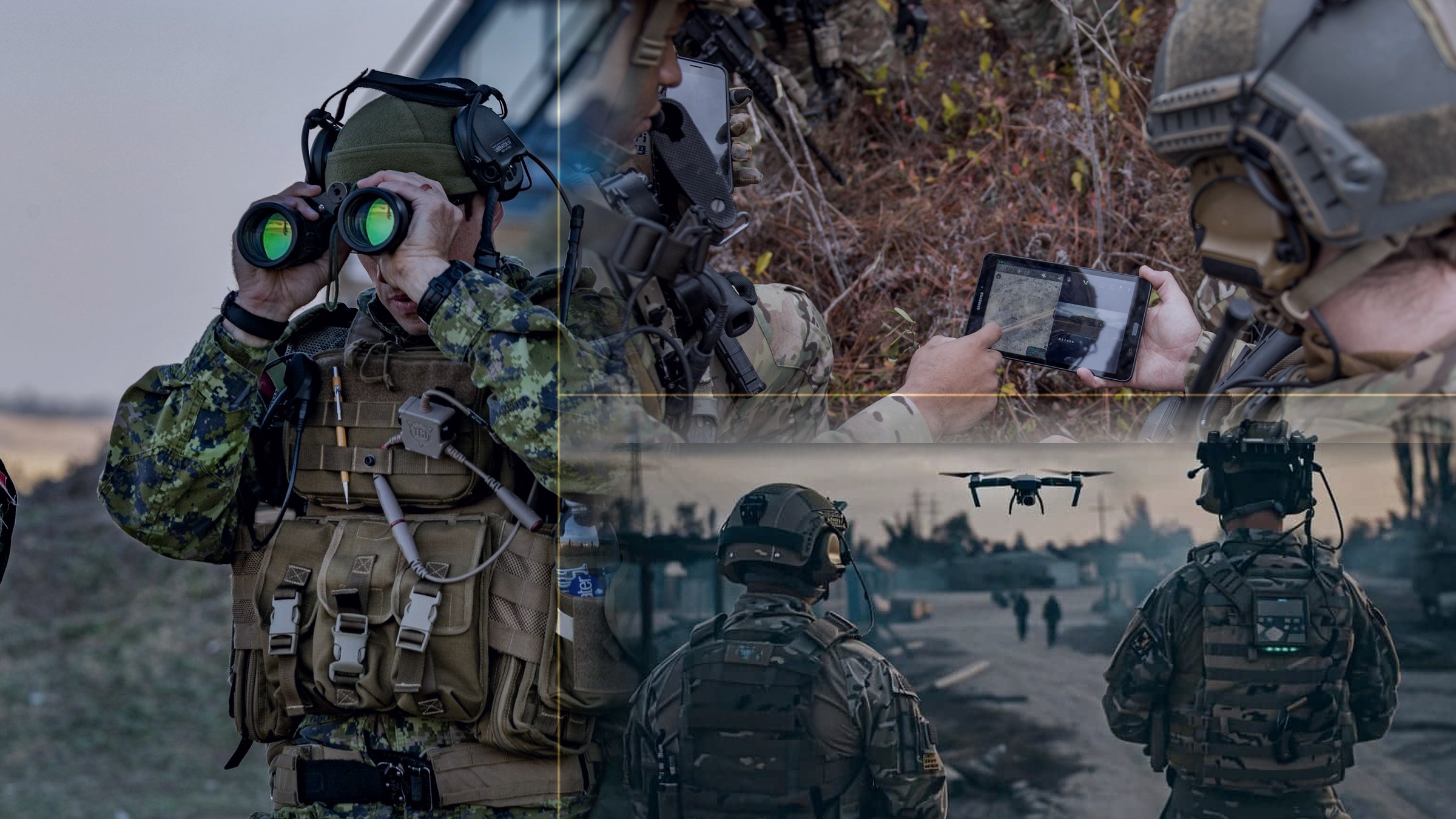
B.U.Combines Group delivers sovereign, TAK-native command and control — from the operator's handheld to the national command centre. Built on GoTAK's operating stack, integrated, fielded and sustained in country by BUCG.
REQUEST A CAPABILITY BRIEFING → EXAMINE THE STACKThey lose because the picture is fragmented. Every service buys its own system, every system speaks its own language, and the commander is left reconciling three screens that disagree. Battle management is not a map — it is the discipline of making one truth available to everyone who needs to act on it.
Air has its picture. Land has another. The border force has a third. Each was procured well and none of them federate. The delay is not in the sensor — it is in the human being asked to translate between systems while the situation moves.
Closed battle management suites bind a nation to one vendor's roadmap, one vendor's release cycle and one vendor's price. Sovereign forces increasingly refuse that trade — they want the picture, the data and the keys held nationally.
TAK is the open situational-awareness standard already fielded across allied forces and agencies. GoTAK turns it into a complete, supported operating stack. BUCG integrates that stack to the end user's platforms, networks and doctrine — and sustains it in country.
The stack is delivered whole — device, radio, sensor, server, plugin and management console arrive configured, certified and federated as a single capability. No layer is sold as a science project.
Hardened Android end-user devices running ATAK — the picture in the hand of the operator on the objective. Privacy-grade, daily-driver and tablet-class platforms, each shipped configured to the unit's data package.
MANET, mesh, DMR, LTE/5G and SATCOM bearers carrying the picture where infrastructure does not reach. Radio nets bridge into TAK rather than sitting beside it, so voice and data share one operating picture.
RF detection, Remote ID, EO/IR, ground sensors, trackers and full-motion video ingested as live tracks on the same map — detection, classification and location resolved where the operator can act on them.
The mission awareness platform — managed TAK server, certificate authority, federation, video management and data ingestion. Cloud, on-premise or forward-deployed on edge compute in a transit case.
Zero-touch enrolment, policy push, kiosk lock, remote wipe and live device health across the whole fleet. A lost device is a revoked certificate, not a compromise — and an entire brigade re-configures from one console.
Server-to-server federation across services, ministries and coalition partners — with gateway integration to legacy command systems and tactical data links so the national picture and the allied picture reconcile.
GoTAK is a veteran-founded, engineering-led defence technology company building TAK-native hardware, software and integration. BUCG carries the full programme set to sovereign end-users across its regions — scoped, delivered and supported locally.
Overwatch, tactical video management, TAK feeds and team control unified in one console — scaling from a single team to organisation-wide deployment. A TAK server stands up in seconds, not procurement cycles.
Enrol, configure and command an entire fleet of Android end-user devices from one console — zero-touch, from the first device to the last. Purpose-built for TAK rather than adapted from a corporate MDM.
Scoped engineering for forces that already know what their picture must do next — sensors, radios, data feeds, legacy systems and mission-specific plugins built, integrated and fielded against fixed deliverables.
The whole kit on a service agreement — equip an exercise or scale an operational rollout from first team to organisation-wide, with the architecture and rollout strategy designed before a device is issued.
Most battle management is sold on architecture diagrams. This is the platform as it actually runs — the screens an operations room, a signaller and a fleet administrator work from every day.
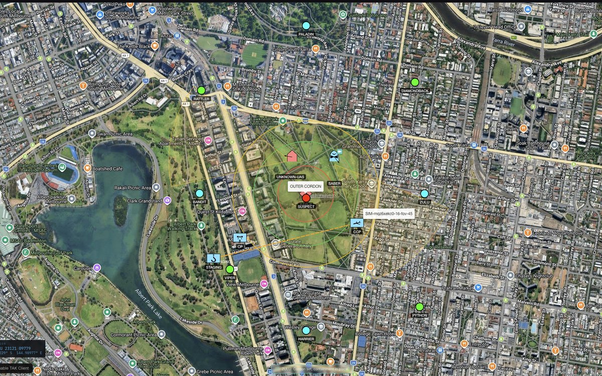
The map every other function reports to. Unit callsigns, cordons and areas of interest, an unknown UAS track, live end-user device positions and a grid-reference cursor readout — one picture the commander and the operator are both looking at.
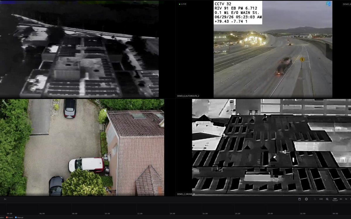
Drone infrared and electro-optical feeds beside fixed and vehicle cameras, node and bandwidth state on the header, and a continuous timeline marking motion, event and manual segments for scrub-back during the mission.
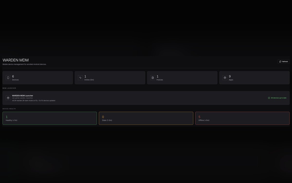
The whole device estate in one view — enrolled count, online against stale against offline, launcher version and how many devices have taken the current build. A brigade re-configures from this screen.
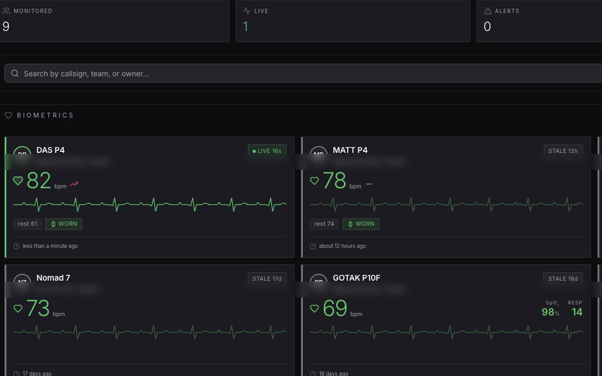
Heart rate, blood oxygen, respiration and resting baseline for every monitored operator, with worn-sensor state and stale-data flags. Casualty indication becomes a reading on the commander’s screen rather than a radio call that never came.
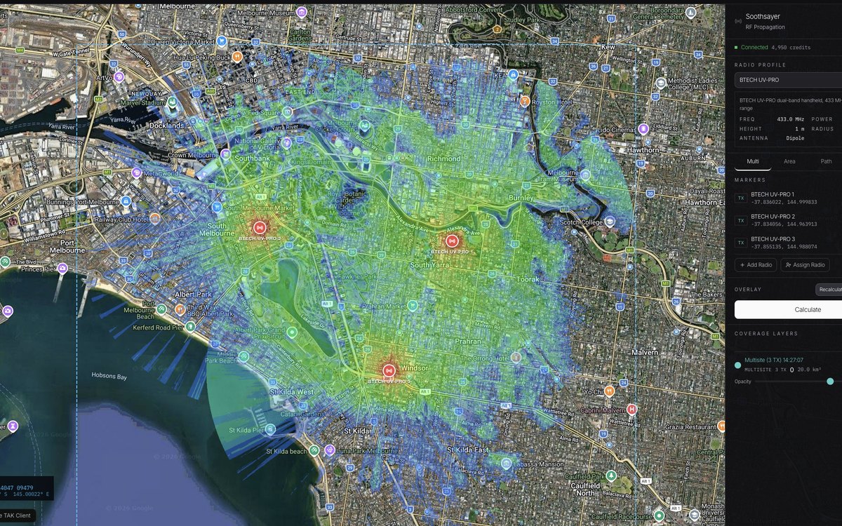
Predicted radio coverage computed against real terrain for a given radio profile — frequency, power, antenna and mast height — with multiple transmitters solved together so the signaller sees the actual footprint before anyone deploys.
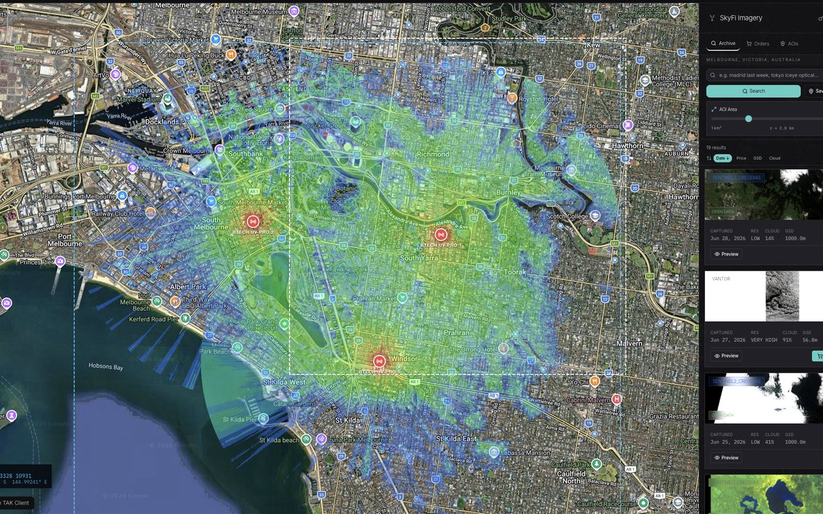
Commercial and open satellite archive searched against a drawn area of interest, filtered by date, resolution, cloud cover and price — from free open-data passes to high-resolution tasking, delivered into the same map.
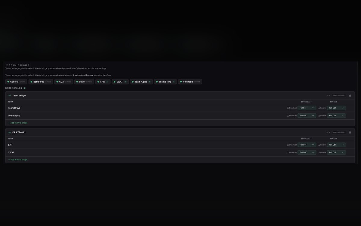
Teams are segregated by default. Bridges are built deliberately, and each team’s broadcast and receive is set independently — so a partner can be given the picture without being given the network. This is PARLEY in operation.
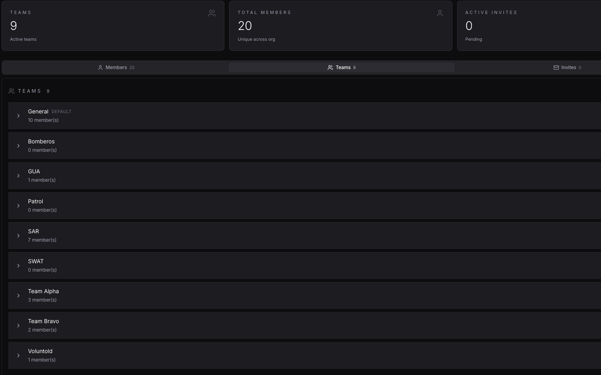
Fire, search and rescue, patrol, tactical and general teams held in one organisation with seats, invitations and membership under central control — the structure that makes a multi-agency incident work on one system.
SABRE is the BUCG mission-fit family — the same core configured, integrated and qualified against the demands of each environment. The fit changes with the role. The operating picture never fragments.
The section, patrol or assault team carrying the picture onto the objective — blue force tracking, contact and casualty reporting, target hand-off and imagery from the operator's own device, on the unit's own mesh.
Vehicle-integrated command with a docked device driving a full crew workspace on vehicle power and antenna, and the troop picture bridged to the dismounted teams the moment the ramp drops.
Rotary and fixed-wing crews holding the same track picture as the ground force — full-motion video down to the team, aircraft position up to the command post, and terminal control worked from a common reference.
Surface picture for naval special operations, coastguard and port security — vessel tracks, boarding-team position, coastal sensor feeds and shore command reconciled on one chart across a contested littoral.
The joint operations room — every domain on one wall, federated down to subordinate formations and out to coalition servers, with recording, playback and after-action review of each track, message and operator action.
Police, border and emergency services on the same standard as the military — multi-agency incident command, search and rescue, event security and critical infrastructure protection, federated but compartmented.
No sovereign force starts from nothing. There are links, terminals and command systems already in service, already certified and already paid for. The BRIDGEHEAD family exists to bring those into one picture rather than ask a nation to abandon them.
Where a force already holds NATO or national tactical data links, BRIDGEHEAD is the scoped gateway that brings that traffic into the SABRE picture — Link 16, Link 11, Link 22 and JREAP-C handled by a qualified multi-link processor, translated to Cursor on Target and correlated against the ground picture. BUCG scopes, integrates and sustains; the link processor itself is a qualified third-party product, selected against the customer's certification requirement.
The national layer beneath every fit — a sovereign federation core, a nationally issued and nationally revoked certificate authority, national data packages and a national symbology and schema baseline. The architecture that makes the picture the nation's own rather than a hosted service. A command and control backbone, not a radio waveform.
Partner-by-partner federation with deliberate release control — what crosses to a coalition or inter-ministry server, which channels, which tracks, at what classification, and revocable at any moment. Built for the reality that a nation federates with several partners who do not federate with one another.
The functional areas a battle management system is judged on — delivered natively, or engineered in under FORGE where a national requirement demands it.
Blue force tracking, track management, correlation, identification and de-confliction — one authoritative picture with contributor attribution.
Air, land, surface and subsurface tracks, areas and points of interest, sensor footprints and named areas of interest maintained live.
Geo-fencing, proximity and breach alerting, triangulation, mission alerts and emergency broadcast to the affected force only.
Passive RF detection, Remote ID exploitation, drone and pilot localisation, and radio network status rendered as map layers.
Route planning, way-pointing, elevation and viewshed analysis, range and bearing tools, and GNSS-denied fallback procedures.
Certificate-based authentication, multi-level roles, compartmented channels and revocation enforced from the management console.
Live health of devices, radios, sensors and server components — with the ability to diagnose and resolve during mission execution.
Continuous archival of tactical data, video and operator actions, with playback for after-action review, training and evidentiary use.
Every device ships hardened, configured to the unit's data package and enrolled in the management console before it leaves. Fielding is issue-and-operate, not issue-and-configure.
Hardened GrapheneOS, fully de-googled — the highest privacy-grade device in the line, built for sensitive operations where the device itself sits inside the threat model.
Hardened Samsung XCover platform running standard services — the daily-driver device for routine and official operations where conventional Android workflows and managed applications are required.
Hardened tablet-class device inside the MAAK ecosystem — the form factor for command posts, vehicle crews and aircrew who need map area without surrendering ruggedisation or kit integration.
The volume-issue device for equipping a formation rather than a team — full ATAK capability and fleet enrolment at a unit price that makes brigade-wide fielding a realistic procurement.
Samsung S23 Tactical Edition — the established government and defence handset standard, configured, hardened and enrolled to the same fleet policy as the rest of the estate.
A fielded provisioning station in a carry-on case — dock, charge and clone one configured ATAK environment across a batch of devices in a single pass, at the exercise or on deployment.
The device puts awareness in the operator's hand. The field kit extends it across the force — comms that reach off-grid, sensors that see past the horizon, and a deployable core that stands the picture up with no reachback at all.
A deployable TAK_OS server node in a carry-on case with onboard edge compute. The team's operating picture stands up locally — with an uplink, or with none at all. The answer to disconnected operations.
Every Remote ID drone on the map in seconds — who is flying, where, and where the pilot is standing. Passive RF detection, receive-only and air-gapped, in a carbon-fibre body that emits nothing.
Converts the crew's device into a vehicle command hub — a full desktop workspace on an external display with keyboard input and windowed applications, built for the tactical environment rather than the office.
Portable 5G and multi-bearer routing for the command post, vehicle or forward node — aggregating whatever transport is available into a single reliable path back to the core.
Real-time position for operators, vehicles, aircraft and high-value assets fed straight onto the map — GPS, mesh and cellular variants so that tracking survives whichever bearer is denied.
A deployable cross-band repeater — in the vehicle, in the ruck, onto the objective. Extends the whole team's range and bridges the radio net into the operating picture rather than leaving it isolated.
Mesh, MANET, DMR, cellular and satellite bearers integrated to TAK with the plugin pre-loaded and server federation ready. The transport layer is selected against the threat and the terrain, not the catalogue.
Infrastructure-independent mesh carrying position and messaging between operators with no network, no subscription and no dependency on a host nation's spectrum authority.
Compact mesh nodes pairing to the operator's device for off-grid position reporting and text — the entry layer for dispersed teams, volunteer agencies and reserve formations.
Multi-hop mesh over DMR — turning an existing digital radio estate into a data-bearing network for TAK, so a force already holding DMR gains the picture without re-equipping.
Handheld radios carrying both voice and TAK data on the same set, with the relay plugin bridging the net into the operating picture for units that live on VHF and UHF.
Professional-grade DMR handsets for police, border and emergency services — the established public-safety standard, integrated to the same operating picture the military formation is using.
Satellite messaging and position reporting beyond all terrestrial coverage — the bearer of last resort that keeps a dispersed team on the map in deep field, maritime and mountain operations.
Modules and plugins developed and maintained in-house — each adding a function to the operator's map without a new device, a new radio or a new procurement.
Brings the handheld radio net onto the map — position, messaging and net status from the radio estate rendered alongside every other track rather than living on a separate system.
Heart rate, blood oxygen, respiration and resting baseline for every monitored operator, with worn-sensor state, stale-data flags and threshold alerting. A casualty becomes a reading on the commander's screen rather than a radio call that never came.
Keeps dispersed and disconnected elements reconciled with the core across satellite transport, so a team beyond terrestrial coverage still holds — and still contributes to — the operating picture.
Ingests third-party tracking hardware as native map tracks — vehicles, assets and personnel across a mixed fleet rendered in one symbology set instead of three separate portals.
Predicted radio coverage computed against real terrain for a given radio profile — frequency, power, antenna type and mast height — with several transmitters solved together. The signaller sees the true footprint, and the gaps, before anyone deploys to fill them.
Commercial and open satellite archive searched against a drawn area of interest and filtered by date, resolution, cloud cover and price — from free open-data passes to high-resolution tasking, delivered straight into the map.
Repeater coverage and satellite pass prediction rendered as map layers, so communications are planned against the same terrain the commander is manoeuvring across.
Street addressing and civil geography for interior, border and emergency operations — plus a lightweight tracker application for personnel outside the hardened device fleet.
A simulation environment for rehearsal and instruction — synthetic contacts, tracks and scenarios exercised through the live console, so operators and staff train on the actual system rather than a classroom mock-up.
TAK federates server to server as a native property — across services, ministries and coalition partners. Where a force also holds legacy command systems or NATO tactical data links, those are bridged in through engineered gateways under FORGE rather than replaced. BUCG states plainly which is which.
| INTERFACE | DELIVERY | NOTE |
|---|---|---|
| TAK · Cursor on Target | NATIVE | The core standard. Devices, servers and plugins speak it end to end without translation. |
| Server federation | NATIVE | Server-to-server federation across units, agencies and allied nations, with compartmented channels and per-partner data policy. |
| Video & FMV | NATIVE | Real-time video ingestion and distribution through the platform's video management service. |
| Sensors & RF detection | NATIVE | Remote ID, passive RF, ground sensors and trackers ingested as live tracks. |
| Radio nets — MANET, DMR, VHF/UHF | NATIVE | Bridged into the picture through the radio relay and mesh plugin set. |
| Legacy C2 & national systems | GATEWAY — ENGINEERED | Scoped integration to in-service command systems, databases and national infrastructure. Delivered as a FORGE engagement against fixed deliverables. |
| NATO tactical data links — Link 16, Link 11, Link 22, JREAP-C | GATEWAY — THIRD PARTY | TAK is not a tactical data link terminal and BUCG does not represent it as one. Where a national requirement includes TDL processing, the picture is bridged through a qualified multi-link gateway and presented in the same COP. Scoped case by case. |
| Air surveillance feeds — ASTERIX and equivalents | GATEWAY — ENGINEERED | Radar and air picture feeds translated to Cursor on Target and correlated against the ground picture. |
A sovereign force cannot accept a command system whose servers, certificates and data sit under another state's jurisdiction, or whose availability depends on a foreign vendor's commercial standing. The architecture BUCG fields is designed to remove that exposure.
The platform is deployed inside the end user's own infrastructure. The certificate authority is issued and held nationally. The data never leaves the territory unless the end user federates it deliberately, to a partner it has chosen, on terms it sets.
This is the same model GoTAK has delivered as a sovereign end-to-end C6ISR capability for allied special forces — and the model BUCG proposes for national command and control programmes across its regions.
Anyone can ship a licence. A battle management programme succeeds or fails on what surrounds it — requirement capture, integration to platforms already in service, training to genuine self-sufficiency, and a support line that answers in the right time zone.
Requirement capture against doctrine and order of battle, evaluation kit in country, and a limited trial with the end user's own operators on their own terrain.
Network, certificate and federation design; hosting and air-gap decisions; data package build; and the interface control work for every system being bridged.
Sensor, radio, vehicle and legacy-system integration delivered under FORGE against fixed deliverables, with field validation before acceptance.
Phased rollout with provisioning at scale, operator and administrator training, and instructor cadre development so the force can train itself thereafter.
In-country field service, spares and repair, configuration management, capability upgrades and a support line held locally through BUCG's regional offices.
The stack BUCG carries is in service with allied forces and agencies. The references below are GoTAK's own programme record as platform originator; BUCG's role is regional prime, integrator and sustainment authority.
GoTAK contracted to deliver a fully sovereign, end-to-end C6ISR capability built on TAK_OS for an allied air force special operations unit — the reference architecture for national command and control modernisation.
Selected for NATO command and control support under a coalition innovation programme, delivered alongside allied industry partners — evidence the stack federates in a multinational environment.
Deployed to a live flood rescue operation providing shared awareness across multiple responding agencies — the same picture discipline applied outside the military use case.
The useful conversation is not a slide pack — it is the system you already hold that refuses to talk to anything else. Bring that, and we will scope what it takes to put it on one map with everything else you operate.